Paper
- Agent-based modelling of post-disaster recovery with remote sensing data
- International Journal of Disaster Risk Reduction, Volume 60, 15 June 2021, 102285
- https://doi.org/10.1016/j.ijdrr.2021.102285
In this recent study, we develop an agent-based model using machine learning-derived information from remote sensing data to simulate and explore the post-disaster recovery processes in urban areas of Tacloban, the Philippines, devastated by Typhoon Haiyan in 2013.
The physical aspects of the recovery are relatively easy to monitor and evaluate using geospatial remote sensing data compared to functional assessments that include social and economic processes. Formal and informal (slum) sector households are differentiated in the model to explore their resilience and different recovery patterns. Machine learning-derived land use maps are extracted from remote sensing images for pre- and post-disaster and are used to provide information on physical recovery.
We use the empirical model to evaluate two realistic policy scenarios: the construction of relocation sites after a disaster and the investments in improving employment options. We find that the speed of the recovery of the slum dwellers is higher than formal sector households also thanks to the availability of low-income jobs in the first months after the disaster. Finally, the results reveal that the households’ commuting distance to their workplaces is one of the critical factors in households’ decision to relocate after a disaster.
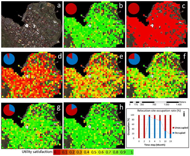
(b-h) spatial distribution of the mean utility satisfaction of households residing in formal (FH) and informal (IH) settlements for steps 0, 2, 3, 4, 5, 10 and 19, respectively; the pie-chart here denotes the occupation ratio of the relocation site at steps 0, 2, 3, 4, 5, 10 and 19, respectively, and (i) is the relocation site occupied and unoccupied ratio for pre-and post-disaster situations. Each time step is equal to a month; the typhoon Haiyan hits the area on step 1 of the simulation.